Implementation of Statistical Geoportals
Work area(s)
Strengthening geospatial capacities of national statistical offices to monitor the 2030 Agenda in Latin America and the Caribbean; Geospatial Facility
This project is executed by the Statistics Division of ECLAC and funded by Pillar II of the Technical Cooperation of the European Union. Its objective is to strengthen capacities in the design, construction and implementation of statistical geoportals in national statistical offices (NSOs) so that they can be able to manage, integrate and visualize geospatially enabled statistical data.
Description
Latin American and Caribbean countries face significant challenges in moving towards e-economies, improving services to citizens, developing capacity to apply geospatial technology, improving informed government decision-making processes using sound official statistics, taking practical actions to achieve a digital transformation, and being able to bridge the geospatial digital divide in the implementation of national strategic and development priorities and the 2030 Agenda for Sustainable Development.
The 2030 Agenda recognizes that timely, available and accessible geospatial and statistical information, both integrated with various types of additional information, are a prerequisite for good policy making and supporting and monitoring development progress. However, there is still a lack of awareness, understanding and assimilation of the vital and integrative role of geospatial information for statistical purposes, particularly in developing countries.
Many countries are establishing integrated and collaborative models to optimize the generation, access, exchange and use of geospatial information so that it can best support the decision-making process and public policies. These models are aligned with the concept known internationally as spatial data infrastructure (SDI), which brings together all the institutional and technological components necessary for the achievement of a proposed goal.
One of the most important SDI actors are the National Statistical Offices, as they provide a huge volume of data on a wide range of topics and often with a significant level of disaggregation. When these data are linked to any geography (administrative unit, cadastral parcel, georeferenced address or other) it is possible to visualize the behavior of variables in the territory, enabling statistics geospatially.
The reality of the region in terms of SDI and geospatially enabled statistics is in transition. The study conducted by ECLAC (2018) indicates that in the Region, even though most national statistical offices use geospatial information in some of their processes, only 42% of them have geoportals to disseminate statistical data, interoperate with other agencies and integrate with other types of geospatial information. This means an important gap in terms of accessibility and interoperability that this project intends to address.
The project “Strengthening geospatial capacities of national statistical offices to monitor the 2030 Agenda in Latin America and the Caribbean” executed by the ECLAC Statistics Division and financed by Pillar II of the European Union Technical Cooperation, aims to strengthen capacities in the design, construction and implementation of statistical geoportals in national statistical offices (NSOs) so that they can be able to manage, integrate and visualize geospatially enabled statistical data.
Objectives
General Objective
- Strengthen capacities in the design, construction and implementation of statistical geoportals in national statistical offices (NSOs) so that they are able to manage, integrate and visualize geospatially enabled statistical data.
Specific objectives
- Consolidate an institutional architecture at the national level related to the statistical and geospatial data ecosystem.
- Foster data exchange between institutions and improve the interoperability of statistical and geospatial information.
- Promote capacity building in statistical and geospatial information.
- Support the improvement of national statistical databases by promoting the use of international standards that facilitate integration into regional statistical databases and geoportals.
- Build and implement a geoportal technological solution for the visualization of statistical and geospatial information.
- Contribute to the measurement and monitoring of the targets and global indicator framework for the Sustainable Development Goals (SDGs) of the 2030 Agenda for Sustainable Development.
Expected results
Implementation of a statistical geoportal whose functionalities are adapted to the requirements of each National Statistical Office involved in the project. This tool will comply with interoperability standards between multiple platforms and will support internal statistical and geospatial data integration processes.
Project Components
| Component 1 | Diagnosis of the current situation regarding the integration of statistical and geospatial data in the national statistical offices of the project target countries and selected countries of the European Union. This diagnosis will consider aspects related to the use of geospatial information in their processes of production and dissemination of statistical data, technical aspects of hardware, connectivity, existence of licenses for geographic information systems, use of standards and geodatabase configuration, among others. This diagnosis is a relevant input for the design component.. |
| Component 2 | Design of a prototype statistical geoportal to be implemented in each of the target countries of the project, which allows the storage, processing and online dissemination (as map services) of geocoded statistical data, with its corresponding disaggregation or aggregation, applying interoperability protocols and standards established by the International Organization for Standardization (ISO) and the Open Geospatial Consortium (OGC). |
| Component 3 | Construction of a statistical geoportal through the development of the applications that make up the software architecture and the functional design of the geoportal. |
| Component 4 | Implementation of the statistical geoportal prototype including software installation, integration with map service, metadata and other public data at the national level. The implementation considers the physical installation of the applications in the institutional servers in accordance with the results of the diagnosis carried out in Component 1. |
| Component 5 | Operation of the statistical geoportal including services to continuously maintain the functioning of the statistical geoportal in the selected countries. |
Main activities contemplated in the project
- Collection of diagnostic information in the target countries through the application of a global questionnaire, country-specific interviews and analysis of available institutional documentation.
- Technical exchange meetings for capacity building on statistical and geospatial interoperability, geocoding of data and use of common geographies, following the guidelines of the UN-GGIM Global Statistical Geospatial Framework.
- Survey of requirements and needs of the National Statistical Offices on the components to be incorporated in the technological solution to be delivered.
- Development and installation of the different components of the technological architecture in the servers of the National Statistical Offices of the target countries. These components include databases, map servers, data and metadata catalogs, and web map application.
- Follow-up and monitoring, to ensure the correct functioning of the statistical geoportal.
Beneficiary countries
The selection of target countries for the project was based on previous diagnostic criteria and their expression of interest. Thus, the beneficiary countries were:
| 1. Argentina | 5. El Salvador |
| 2. Costa Rica | 6. Guatemala |
| 3. Dominican Republic | 7. Honduras |
| 4. Ecuador | 8. Paraguay |
Statistical geoportals in operation
|
Argentina: Portal Geoestadistico Costa Rica: Portal Geoestadistico Ecuador: Portal Geoestadistico Paraguay: Portal Geoestadistico Dominican Republic: Geoportal ONE |
News:
-
 6 Dec 2024 | Briefing note
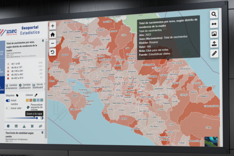
Costa Rica launches new statistical geoportal to enhance the use of geospatial data
The National Institute of Statistics and Census (INEC) of Costa Rica presented an innovative tool that integrates statistics and geospatial data, facilitating decision-making and the design of public policies. This development, supported by ECLAC and the European Union, allows users to access information disaggregated by territory, strengthening the country's data infrastructure.
-
 7 Dec 2023 | Briefing note
The National Institute of Statistics of Paraguay launches its new Geostatistical Portal
A geoportal is a web application whose purpose is to offer users access to a series of resources and services based on geographic information, enabling integration, interoperability, and the exchange, in this case, of statistical information.
-
 30 May 2023 | Briefing note
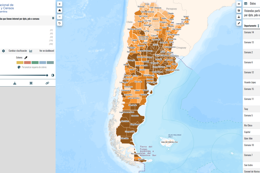
New Statistical Geoportal of INDEC, Argentina
A geoportal is a web application whose purpose is to offer users access to a series of resources and services based on geographic information, enabling integration, interoperability and the exchange, in this case, of statistical information.
-
 1 Mar 2023 | Briefing note
Technological tools for the dissemination of disaggregated statistics in the territory
Follow-up meeting of the ECLAC project on the implementation of statistical geoportals in 8 countries of the region. The meeting was held within the framework of the 54th session of the United Nations Statistical Commission.
Country(ies)
-
 Argentina
-
 Costa Rica
-
 Dominican Republic
-
 Ecuador
-
 El Salvador
-
 Guatemala
-
 Honduras
-
 Paraguay