Décima sessão do UN-GGIM: Américas
Work area(s)
Topic(s)
Teaser
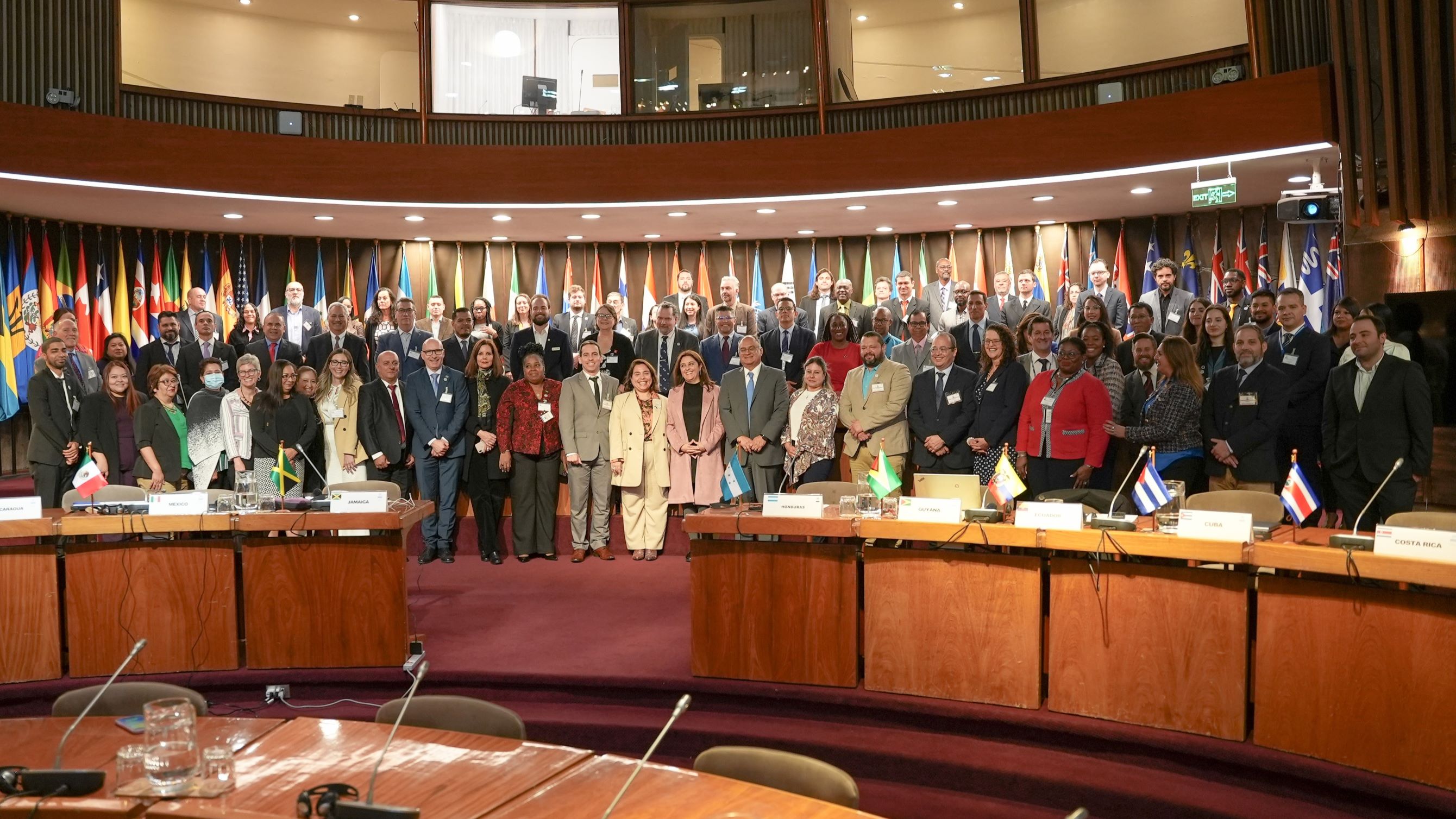
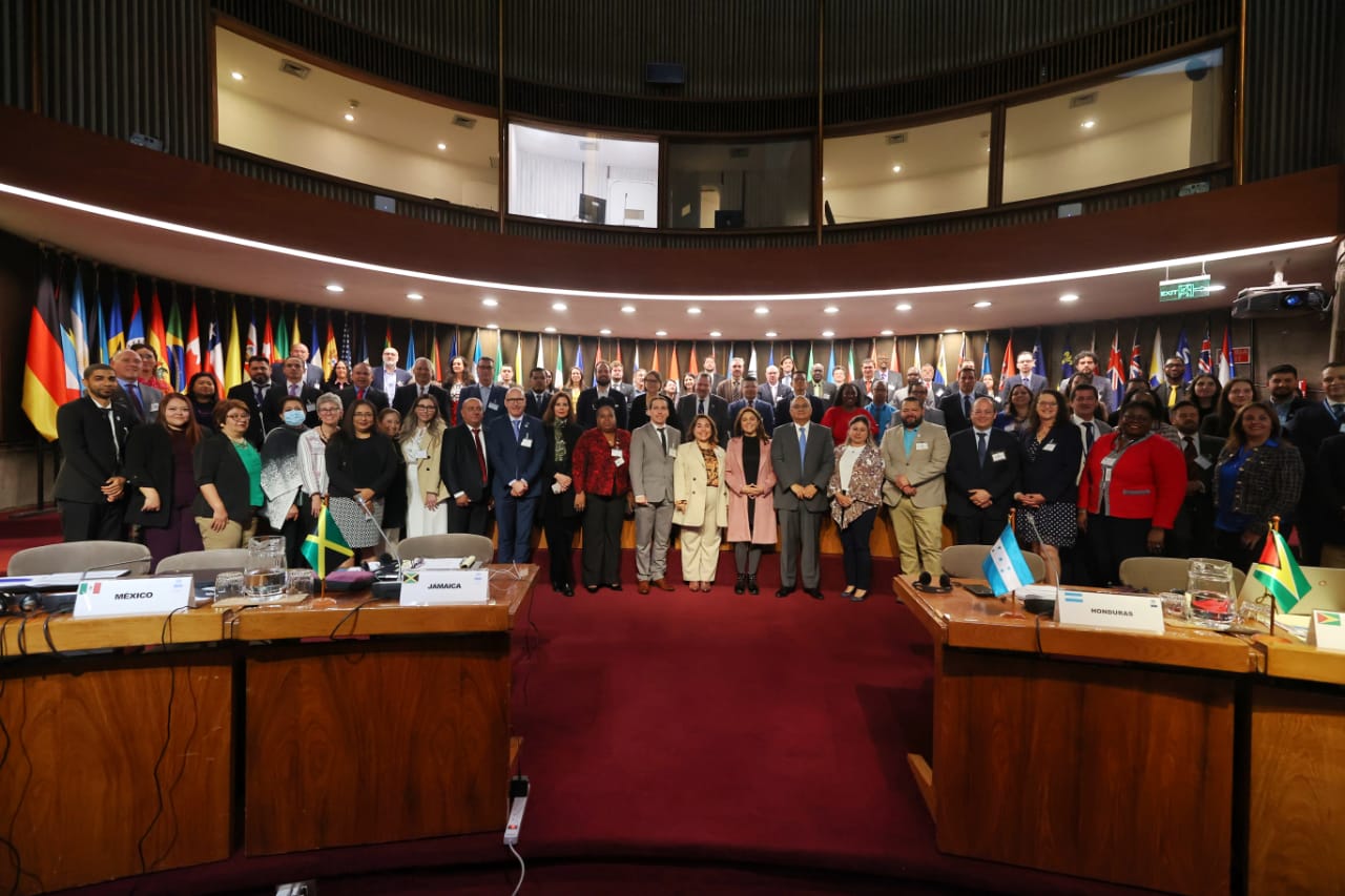
A décima sessão do Comitê Regional das Nações Unidas sobre Gestão Global da Informação Geoespacial para as Américas (UN-GGIM: Américas), bem como os eventos paralelos, ocorreram de 17 a 20 de outubro de 2023, presencialmente na sede da CEPAL.
Event information
Data
17 - 20 Out 2023, 06:00 - 15:00Event type
Participation
A Décima Sessão do Comitê Regional das Nações Unidas sobre Gestão Global de Informações Geoespaciais para as Américas (UN-GGIM: Américas) tem como objetivo monitorar o progresso da agenda de trabalho do Comitê Regional em relação à implementação das diretrizes geoespaciais globais das Nações Unidas em seus Estados-membros. Da mesma forma, promover espaços de colaboração e intercâmbio para fortalecer os processos e iniciativas nacionais de gestão da informação geoespacial.
Programme of work
Ceremonia de inauguración
▪ Rolando Ocampo, Director de la División de Estadísticas de la CEPAL
▪ Marcela Sandoval, Ministra de Bienes Nacionales de Chile
▪ Paloma Merodio, Copresidenta de UN-GGIM
▪ Stefan Schweinfest, Director de la División de Estadísticas de las Naciones Unidas (UNSD)
▪ Paula Narváez, Presidenta del Consejo Económico y Social (ECOSOC) de las Naciones Unidas
Presentation(s)
Celebrando 10 años de UN-GGIM: Américas / Celebrating 10 years of UN-GGIM: Americas
Verificación del quórum y aprobación de la Agenda / Verification of quorum and approval of the agenda
Fotografía oficial / Official photo
Sesión 1: Informe regional
Presentation(s)
Report of the UN-GGIM Americas Regional Committee 2022-2023
Sesión 2: Herramientas para la difusión de información geoespacial regional
Presentation(s)
Presentación Sitio web de UN-GGIM Américas / Presentation UN-GGIM: Americas Website
Lanzamiento Sitio Web IDE Américas / Presentation Website IDE Americas
Sesión 3: Redes regionales y colaboración
Sergio Cimbaro, Vocal América del Sur
Introducción a la sesión
Presentation(s)
Mapping the Future : The Private Sector Network’s Contribution to UN-GGIM Americas
The Pan American Institute of Geography and History and its cooperation with various agencies of the Inter American System
AI-Based On-Demand Mapping: A Future for Collaboration
El futuro cartográfico es colectivo: los aportes de Openstreetmap a las cartografías oficiales / The cartographic future is collective: Openstreetmap's contributions to official cartographies
Cierre de la sesión / Closing the session
Sesión 4: Situación, necesidades y desafíos de los Estados Miembros del Comité Regional
Presentation(s)
- Status and challenges of UN-GGIM Americas, work plan (2021-2025)
Resumen y palabras finales / Summary and final words
Video dia 2
[[{"fid":"143858","view_mode":"default","fields":{"format":"default","alignment":""},"type":"media","field_deltas":{"1":{"format":"default","alignment":""}},"attributes":{"class":"media-element file-default","data-delta":"1"}}]]
Intervención UN-GGIM: Estados Árabes
Mohammad Almabrook, UN-GGIM: Estados Árabes
Sesión 5: Foro del Marco Integrado de Información Geoespacial (UN-IGIF)
Gabriela García Seco, Vocal de Norteamérica
Introducción a la sesión
Presentation(s)
The HLG-IGIF: Advancing the UN-IGIF to Address National and Regional Drivers for Change
- Integrated Geospatial Information Framework Working Group for the Americas
- Dashboard 2023 Survey Results - UN-GGIM: Americas
Preparing UN-IGIF country-level action plans: the UN approach and the SDG Data Alliance
Supporting the UN-IGIF implementation in the region
Espacio de discusión “Avances y casos de uso en la Implementación del UN-IGIF
Presentation(s)
The UN-IGIF in México: Progress and challenges in implementation
Current status of the integrated geospatial information framework in Panama
Cierre de la sesión / Closing the session
Sesión 6: Foro del Marco Geoespacial Estadístico Global (GSGF)
Simone Lloyd, Vocal del Caribe
Introducción a la sesión
Presentation(s)
Why do we need to integrate geospatial and Statistical Information?
Prospects for the integration of statistical and geospatial information in the Americas
Supporting GSGF implementation in the Americas
Espacio de discusión “Integración de Datos Estadísticos y Geoespaciales para la Implementación del GSGF"
Presentation(s)
Promotion in the Integration of Statistical and Geospatial Data at INEC - Costa Rica
Geostatistical Portal of the Dominican Republic and GSGF
Canada’s collaborative work to promote GSGF guidelines for integrating statistical and geospatial information
Closing the session
Sesión 7: Grupos de Trabajo de UN-GGIM: Américas
Moderadora/Moderator: Sofía Nilo Crisóstomo, UN-GGIM: Américas
Presentation(s)
SIRGAS Challenges: Geodetic Reference Framework for the Americas (GRFA)
Progress on goals of the disaster group work plan
Implementing the Framework for Effective Land Administration (FELA): New Workplan and Developments
Sesión 8: Vocalías
Pamela Castillo, UN-GGIM: Américas
Introducción a la sesión
Presentation(s)
Sesión 9: Clausura
| Sofía Nilo Crisóstomo, Presidenta de UN-GGIM: Américas Resoluciones de la Décima sesión de UN-GGIM: Américas |
| Sofía Nilo Crisóstomo, Presidenta de UN-GGIM: Américas y Rolando Ocampo, Director de la División de Estadísticas de la CEPAL Comentarios finales |
Eventos paralelos
၀ 10:00 - 13:00
Industry and academia bridge the gap
Organiza: Red Académica y Red Sector Privado UN-GGIM: Américas
Idioma: Inglés (sin traducción)
၀ 11:30 - 13:00
Why Standardize Geographical Names and the UN-GGIM, UNGEGN Collaborative Project
Organiza: División de Estadísticas de las Naciones Unidas (UNSD)
Idioma: Inglés (sin traducción)
၀ 14:00 - 16:00
CARIGEO Session 1: Sharing Knowledge and Best Practices
Organiza: CARIGEO
Idioma: Inglés (sin traducción)
၀ 14:30 - 17:30
Consolidando la Red Académica de las Américas
Organiza: Red Académica UN-GGIM: Américas
Idioma: Español (sin traducción)
Eventos paralelos
၀ 08:30 – 09:50
Conversation “Female leadership in the geospatial field"
Organiza: UN-GGIM: Américas
Idioma: Inglés (sin traducción)
၀ 13:30 – 14:40
CARIGEO Session 2: Advancing CARIGEO
Organiza: CARIGEO
Idioma: Inglés (sin traducción)
Eventos paralelos
၀ 08:30 – 09:50
Open Source for Geospatial Management in IGIF Implementation
Organiza: GeoLibres
Idioma: Inglés (sin traducción)
Video dia 1
[[{"fid":"143853","view_mode":"default","fields":{"format":"default","alignment":""},"type":"media","field_deltas":{"1":{"format":"default","alignment":""}},"attributes":{"class":"media-element file-default","data-delta":"1"}}]]
Video dia 3
[[{"fid":"143870","view_mode":"default","fields":{"format":"default","alignment":""},"type":"media","field_deltas":{"1":{"format":"default","alignment":""}},"attributes":{"class":"media-element file-default","data-delta":"1"}}]]
Related content
Países reafirman valor de la información geoespacial y ratifican su compromiso con la promoción de su aplicación para aportar al desarrollo sostenible de la región
La Décima Sesión del Comité Regional en Gestión Global de Información Geoespacial para las Américas (UN-GGIM Américas), se inauguró hoy en la sede de la CEPAL en Santiago, Chile.
Related project(s)
Organizing institution
Comisión Económica para América Latina y el Caribe (CEPAL)
- https://www.cepal.org
- 56 222100000
Comité Regional de las Naciones Unidas sobre la Gestión Global de Información Geoespacial para las Américas
- http://www.un-ggim-americas.org/
- telephone