Ninth Session of UN-GGIM: Americas
Work area(s)
Teaser
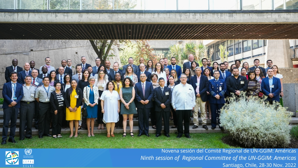
The Ninth Session of the United Nations Regional Committee for Global Geospatial Information Management for the Americas (UN-GGIM: Americas) was held in Santiago, from November 28 to 30, 2022.
Event information
Date
28 - 30 Nov 2022, 06:30 - 14:00Event type
The Ninth Session of the United Nations Regional Committee for Global Geospatial Information Management for the Americas (UN-GGIM: Americas) was held in Santiago, at ECLAC headquarters, from November 28 to 30, 2022. The meeting was organized between UN-GGIM: Americas and ECLAC, which fulfills the role of Technical Secretariat.
The objective of this meeting was to share progress and project future actions of the work agenda of this regional committee, focused on strengthening national geospatial information management processes; support the integration of statistical and geospatial information; and promote the use of geospatial information to support disaster response. Likewise, to examine opportunities for collaboration between countries and also from other geospatial organizations in the region that will participate in the event.
This committee is part of the regional architecture of the United Nations global body on this matter (UN-GGIM), which reports to ECOSOC and has a rich work agenda focused on strengthening the use of geospatial information to support decision-making and public policies, with special attention to the 2030 Agenda for Sustainable Development. UN-GGIM: Americas was created in 2013 with the objective of strengthening national geospatial information management processes in the countries of the region, based on the implementation of the guidelines generated by the UN-GGIM Committee of Experts at the global level. The presidency for the period 2021-2025 falls on Chile through the National System for Coordination of Territorial Information (SNIT) of the Ministry of National Assets of Chile, the agency that leads the development of the national geospatial data infrastructure (IDE-Chile).
This was the first time that this regional meeting is held at ECLAC premises, with the participation of delegations from 22 countries, composed of the directors of national geospatial agencies and other expert organizations in the field.
Programme of work
Welcome and opening remarks
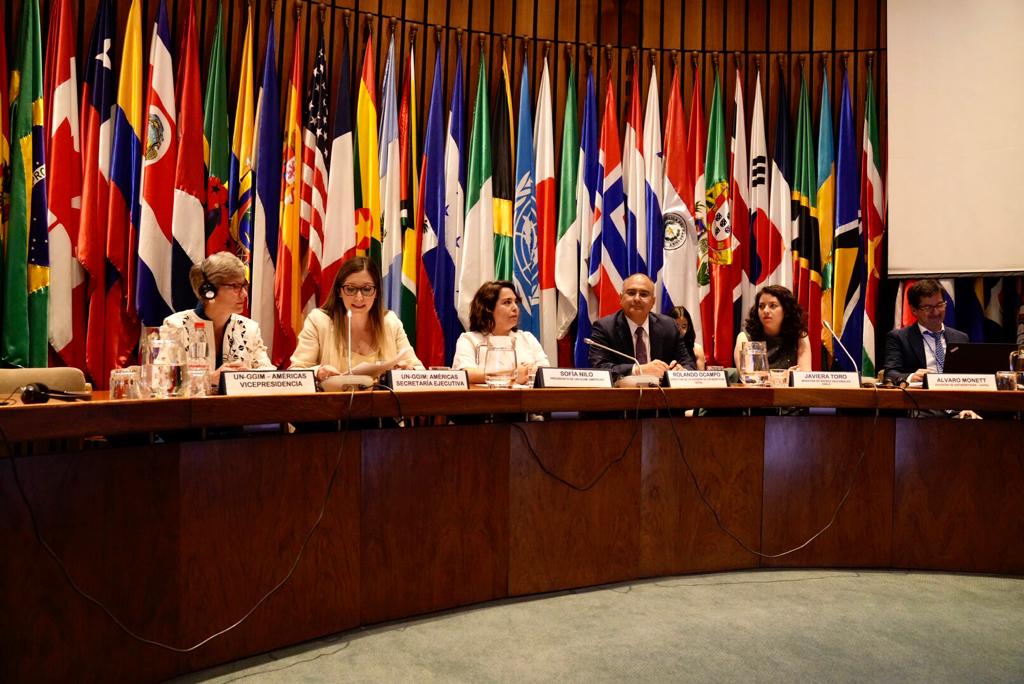
▪ Sofía Nilo Crisóstomo, President of UN-GGIM: Americas.
▪ Rolando Ocampo, Director of the ECLAC Statistics Division.
▪ Stefan Schweinfest, Director of the United Nations Statistics Division.
▪ Paloma Merodio, Co-President UN-GGIM
▪ Javiera Toro Cáceres, Ministra de Bienes Nacionales, Chile
Presentation(s)
- Verificación quórum y aprobación de la Agenda / Quorum verification and approval of the Agenda
Session 1: Presentation of regional reports
Presentation(s)
Session 2: New tools for regional geospatial information dissemination
Presentation(s)
Session 3: Situation, needs and challenges of the Member States of the Regional Committee
- Moderator: Sofía Nilo Crisóstomo, UN-GGIM: Americas
Presentation(s)
Regional Guidelines for the UN-GGIM: Americas 2021-2025 Workplan
» Intervenciones de los países / Country interventions
Session 4: Workshop on Integrated Geospatial Information Framework (IGIF)
Presentation(s)
Introducción / Introduction
High- level Group of the Integrated Geospatial Information Framework, IGIF
Presentación del Grupo de Trabajo “Marco Integrado de Información Geoespacial”
Implementing the United Nations Integrated Geospatial Information Framework (IGIF) at country-level
Espacio de discusión “Necesidades y desafíos regionales para la implementación del IGIF”
Sesión 5: Regional Collaboration
» Presentation of the day's agenda
Presentation(s)
» Introducción / Introduction
Aportes desde la Red Académica UN-GGIM: Américas / Contributions from Academic Network UN-GGIM: Americas
Private Sector Network: updates and the way forward
» Intervenciones de los países / Country interventions
SIRGAS and GRFA WG UN-GGIM:Americas interactions for sustainable geodesy in the Americas
Pan American Institute of Geography and History (PAIGH) and its concrete actions to support the application of the Integrated Geospatial Information Framework (IGIF) in America
AmeriGEO's contribution to the joint plan: the new generation of the international academy american
» Intervenciones de los países / Country interventions
Session 6: Thematic events “Looking to the future”
Presentation(s)
» Introducción / Introduction
Centro Regional de las Naciones Unidas para Big Data / United Nations Regional Hub for Big Data
Tecnologías para una IDE / Technologies for an SDI
» Moderadora / Moderator: Vocal del Caribe / Vocal of the Caribbean, UN-GGIM: Americas
» Intervenciones de los países / Country interventions
Session 7: Workshop Global Statistical and Geospatial Framework
Presentation(s)
» Introducción / Introduction
The GSGF and beyond – Geospatial-statistical integration for our future
Perspectives for the integration of statistical and geospatial information in the Americas
National Geographic and Statistical System Bolivarian Republic of Venezuela
Statistical and geospatial data interoperability: CEPALSTAT Geoportal
Espacio de discusión “Necesidades y desafíos regionales para la implementación del GSGF” / Discussion space: Regional needs and challenges for the implementation of the GSGF
Session 8: Strategic Framework for Geospatial Information and Services for Disasters
Presentation(s)
» Introducción / Introduction
Global Perspective: UN-GGIM WG Disasters
Presentación del Grupo de Trabajo “Marco Estratégico de Información y Servicios Geoespaciales para Desastres”
From building spatial infrastructures to addressing policy priorities for decision making:Canadian perspective
Population living in risk areas in Brazil
Geoinformation management in response to disasters in Ecuador, case study: the Action of the IGM in the Earthquake 06/2016
» Intervenciones de los países / Country interventions
Session 9: Geodetic Reference Framework for the Americas Working Group
Presentation(s)
» Introducción / Introduction
UN Subcommittee on Geodesy (SCoG) Update
The Implementation of GGRF in the Americas Global Geodetic Reference Frame for the Americas
» Intervención de países
Cierre de la novena sesión del Comité Regional de UN-GGIM: Américas
| Sofía Nilo Crisóstomo, UN, GGIM: Américas Resoluciones Novena Sesión UN, GGIM: Américas |
| Palabras de cierre ▪ Sofía Nilo Crisóstomo, UN, GGIM: Américas ▪ Rolando Ocampo , División de Estadísticas de la CEPAL |
Related content
Más de 20 países se reúnen en la CEPAL para promover la cooperación en la gestión de datos geoespaciales y estadísticos
La Novena Sesión del Comité Regional UN-GGIM Américas y la séptima reunión de expertos en integración de información estadística y geoespacial se realizan en la sede del organismo, del 28 de…

Seventh meeting of the Expert Group on the Integration of Statistical and Geospatial Information
This team of specialists, created in 2013 under the auspices of the United Nations Statistical Commission and UN-GGIM, proposes guidelines, methodologies and standards to link statistical data to a…
Attachment(s)
Related project(s)
Organizing institution
Economic Commission for Latin America and the Caribbean (ECLAC)
- https://www.cepal.org
- 56 222100000
United Nations Regional Committee on Global Geospatial Information Management for the Americas
- http://www.un-ggim-americas.org/
- telephone
Contact
Pamela Castillo
- pcastillo@mbienes.cl
Álvaro Monett
- alvaro.monett@cepal.org
- (56-2) 2210 2197