Over 60% of Land in Some Countries
could be Degraded by 2100
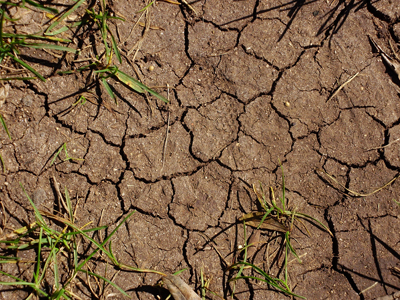
Land degradation, or the loss of biological and economic productivity of the soil, is affecting a large part of the region. It occurs slowly and its effects are usually evident in the long-run, but the deterioration is irreversible or very difficult to recover. Added to this phenomenon are significant migration movements, both productive and human.
From 1982 to 2002, additional degraded areas totaled 16.4% of the territory of Paraguay, 15.34% of Peru and 14.15% of Ecuador, according to the Global Land Degradation Assessment Model (GLADA).
If this trend continues to the year 2100 (the recommended horizon for studying the impact of climate change), it is estimated that 66.3% of the territory of Paraguay, 62% of Peru and 57.2% of Ecuador will become degraded areas.
The main causes of this degradation are erosion due to deforestation, the overexploitation of land for agriculture and contamination with chemical products.
In addition to this direct human impact, towards 2100 it is highly probable that climate change will reduce agricultural GDP by 28%, 9.6% and 18% in Paraguay, Peru and Ecuador, respectively.
| Degraded areas in 2050 and 2100 (%) | |||||||||||||||||||||||||||||||
|
|||||||||||||||||||||||||||||||
| Loss in Agricultural GDP, esc. A2 of IPCC1 | |||||||||||||||||||||||||||||||
|
1An Unfavourable Scenario. See the Fourth Report of the Intergovernmental Panel on Climate Change
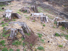
The destruction of the plant surface, in particular deforestation due to lumber and agricultural production, produces greenhouse gas emissions. Along with the energy sector, changes in land use are among the main sources of emissions in Latin America and the Caribbean.
The rise in temperatures and changes in precipitations produced by growing emissions affect productivity and the process of land degradation, for example, by increasing aridity and the number of dry months a year (relation between precipitations and evapo-transpiration), concentrating precipitations during the year and making them more aggressive. The soil lays exposed to erosion by wind and water, among other factors.
The estimates of the regional project “Economic Valorization of Land Degradation in Alternative Scenarios of Climate Change” conducted by ECLAC and the Global Mechanism of the UN Convention to Combat Desertification show an increase in temperatures with a reduction or rise in current precipitations, a trend that will intensify towards the end of century, especially in new agricultural areas, due to deforestation, increasing cattle and livestock raising, and the use of new lands for highly-profitable export crops.
The studies carried out in the region on the vulnerability to degradation caused by climate change (Regional Studies on the Economics of Climate Change, RECCs) reveal the areas that will be most affected. Among them are the agricultural border zones in highly fragile eco-systems, such as the Amazon jungles in Colombia, Ecuador and Peru, where deforestation, farming, cattle and livestock raising and informal gold mining cause severe degradation.
In Ecuador, climate change will affect degraded areas only marginally during the first half of the 21st century: only 6.69% of these areas will be exposed to more aggressive precipitations in 2050 and 19.27% will suffer greater pressure due to dry months.
In contrast, 8.42% of degraded lands will diminish their aridity, but this does not mean that degradation will remain stable in Ecuador. It means that in the first half of this century, it will be caused mainly by human activity. However, during the second half of the century, direct degradation will be compounded as a result of climate change.
Towards the end of the century, temperatures and precipitations in Paraguay will rise, even in the Chaco region, and their strong seasonality will deepen vulnerability to erosion and degradation.
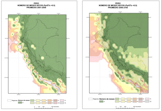
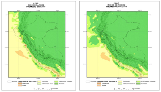
Aridity will diminish in the north of Peru due to rising precipitations, but like in Paraguay, its marked seasonality and concentration in few months will increase vulnerability to degradation.
In Chile, hyper-arid, arid and semi-arid land areas will expand between 2008 and 2050 due to rising temperatures and diminishing precipitations, making a large part of the territory increasingly vulnerable. As a result, the main farming zone in the country will shift south, implying new investments, for example in irrigation for current agricultural areas and to make farming viable in new ones.
The maps of Peru and Bolivia show that the number of dry months will increase between 2008 and 2100, while aridity will diminish due to greater precipitations. However, the vulnerability of the land to degradation will rise, because rains will concentrate in shorter time periods.
An adequate process of adaptation to these impacts requires a timeframe of analysis of over 50 years for a more precise forecast of the economic consequences of climate change. The location of the impacts is also crucial, and this demands an enormous scientific effort in order to specify climate data, disseminate the analyses and reconsider long-term planning policies.
For more information, see the electronic library on climate change available on the webpage of ECLAC’s Sustainable Development and Human Settlements Division.
*by the Sustainable Development and Human Settlements Division of ECLAC
|
||||||
|
||||||

|
||||||

|
||||||

|
|
|
|
| Towards the year 2010, 66.3% of the territory of Paraguay, 62.0% of Peru and 57.2% of Ecuador may be degraded areas. | |
|
|
| Rising temperatures and the changes in precipitations caused by greater greenhouse gas emissions will intensify degradation. | |